


Drone thermal surveys
See exactly where your building is losing heat or letting water in, with radiometric thermal imaging captured from the air.
Available Files: Thermal Imagery & Thermographer Reports
IR
Radiometric Imagery
None
Access Required
Level 2
Thermographer
0
Days of Scaffold
Thermal Imaging Surveys
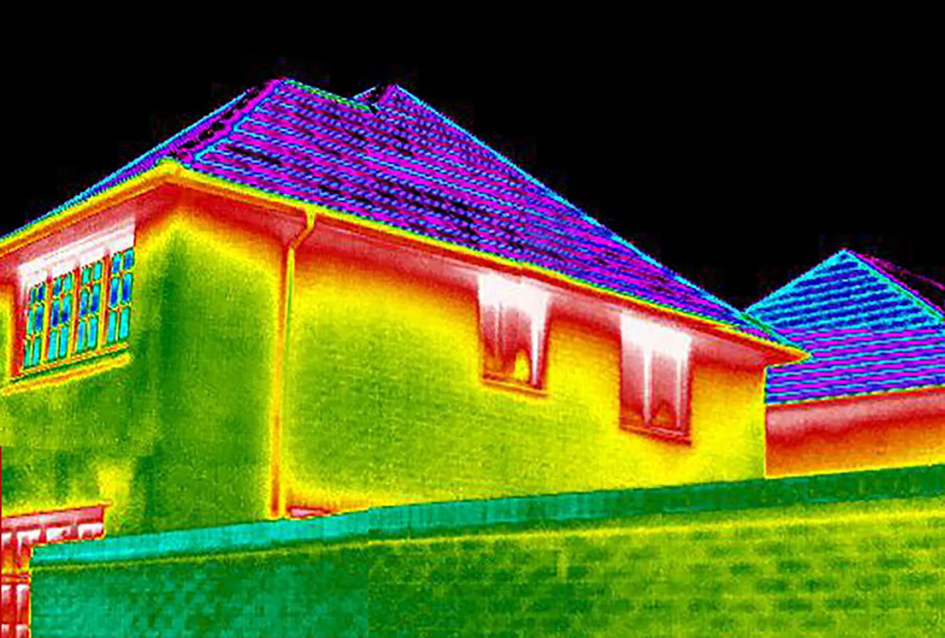
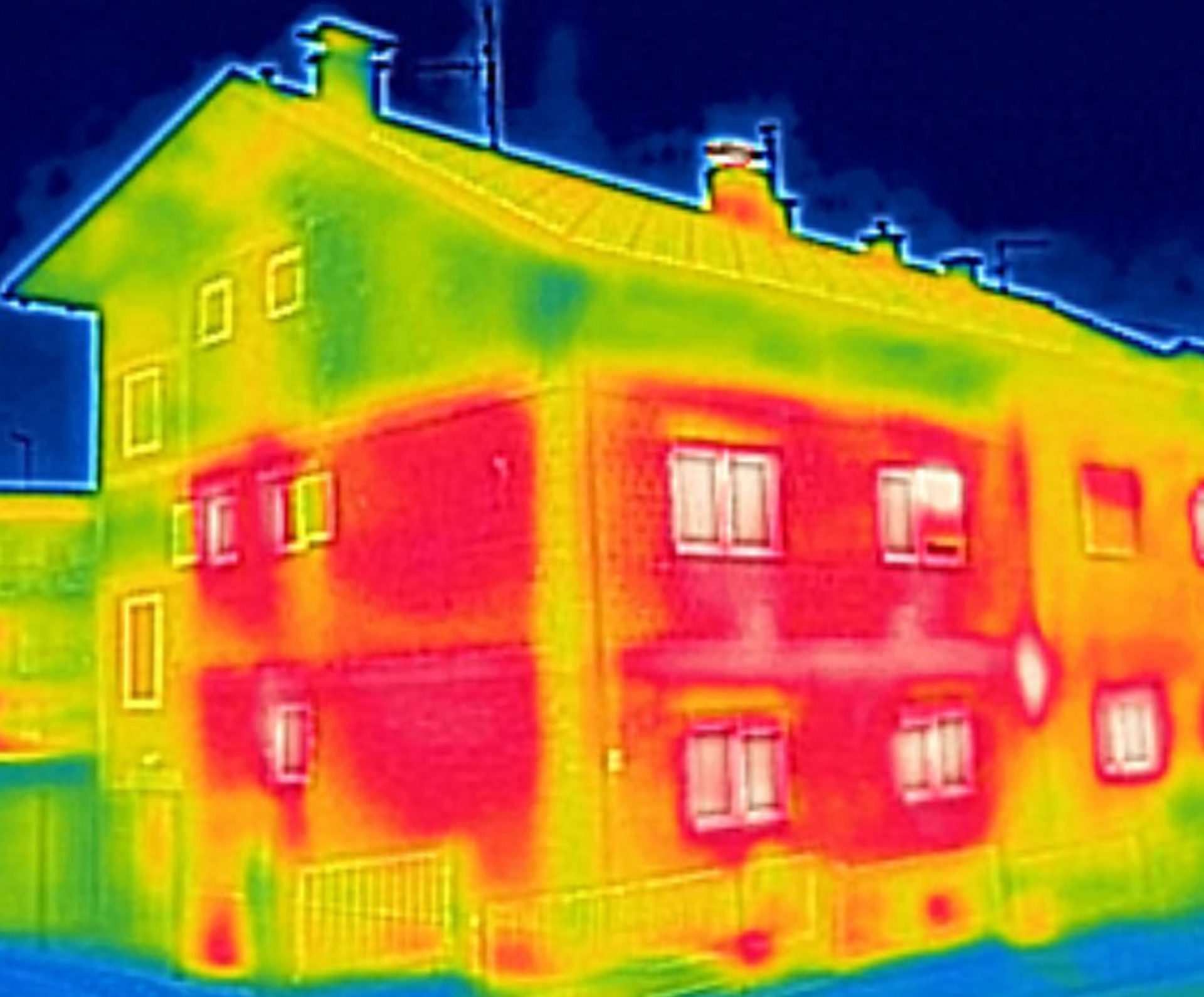
Drone thermal surveys use a radiometric thermal camera to show what the naked eye can’t: heat loss, missing insulation, cold bridging and water ingress. Any building, domestic or commercial, can benefit.
Flying the camera gives us a clear view of every elevation and the whole roof, including areas you can’t see from the ground. Our Bindt Level 2 qualified thermographers then tune and interpret the images, so you know which anomalies matter and which don’t.
Finding problems early means repairs can be targeted instead of guessed, avoiding expensive, invasive investigation work, cutting energy bills and reducing your carbon footprint.
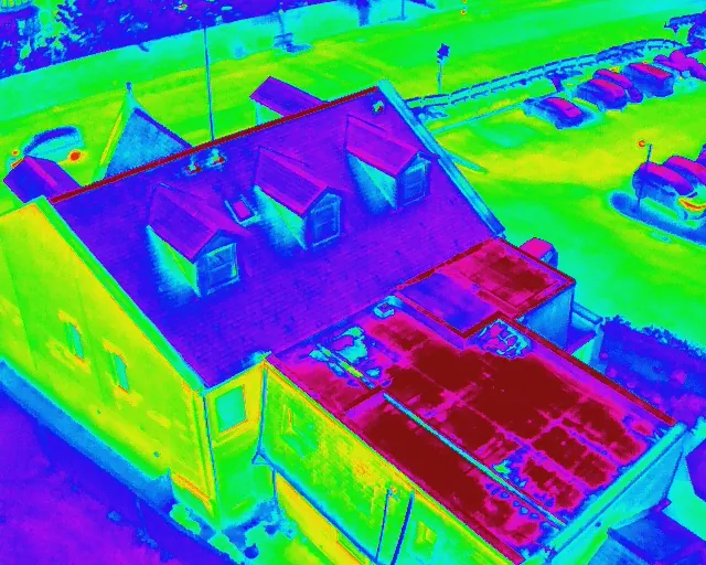
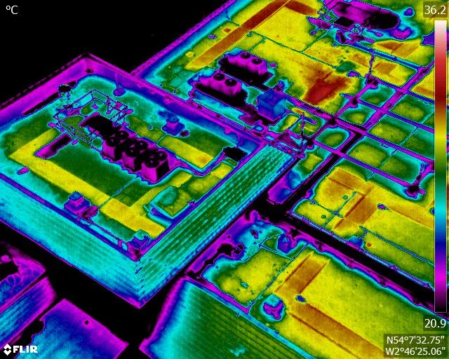
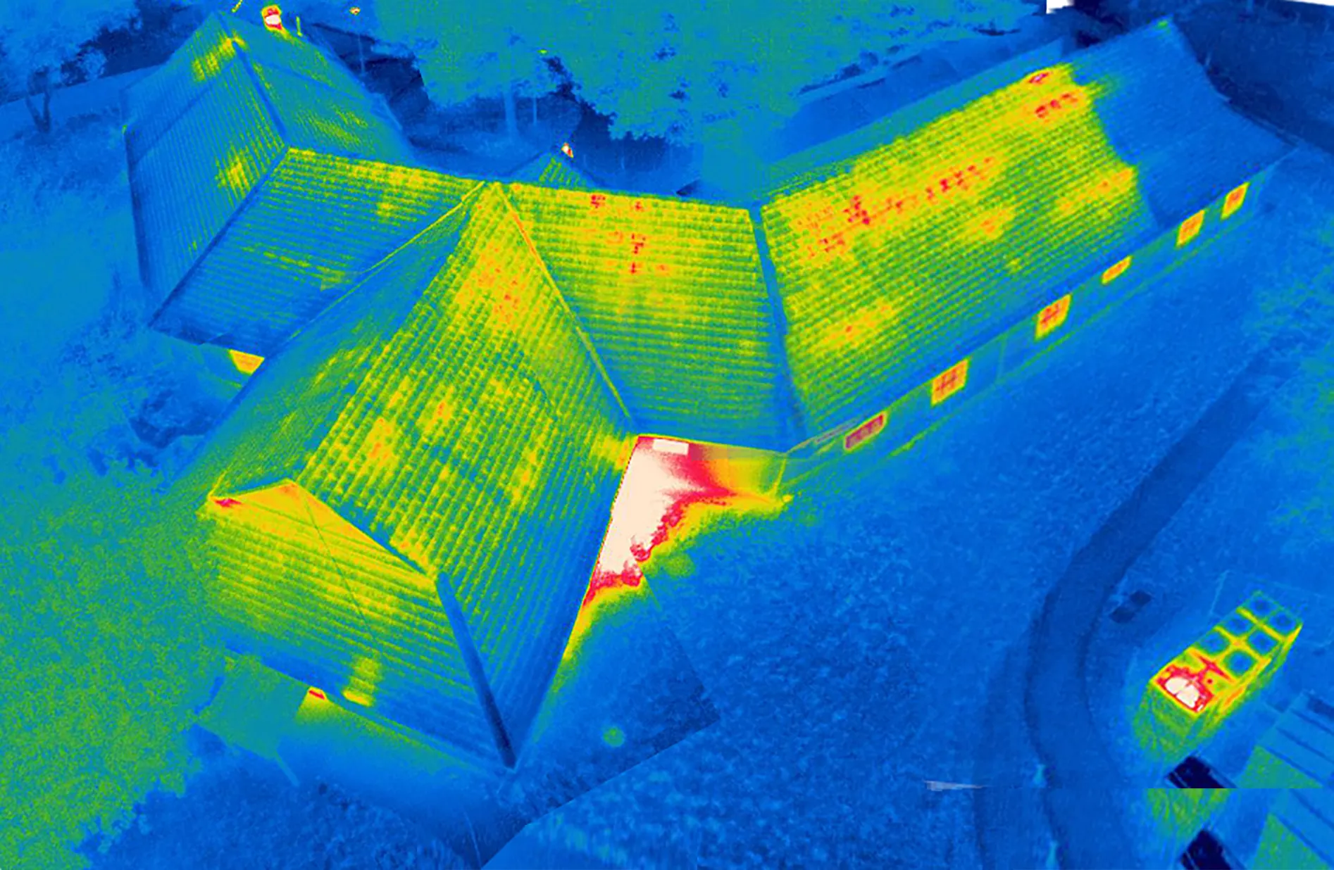
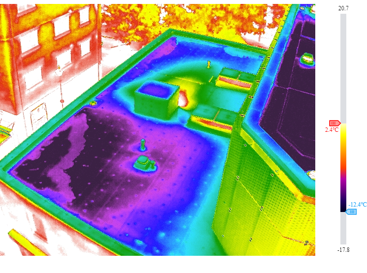
Example Image Quality
Click each image to view example image quality
What Your Thermal Survey Includes
Every thermal survey pairs radiometric thermal images with matching 4K visuals, delivered digitally and ready to share with your contractors.
| Deliverable | What it is | Included |
|---|---|---|
| Radiometric thermal imagery | Temperature data is stored in every pixel, so readings can be checked and re-analysed after the flight. | Standard |
| Matching UHD 4K imagery | Visual images of the same areas, so every thermal anomaly can be located on the building. | Standard |
| Organised by elevation | Images sorted into folders by elevation and roof area, so it’s easy to find what you need. | Standard |
| Digital delivery | A secure download link, ready to share with contractors, insurers or colleagues. | Standard |
| Thermal roof map | Thermal images stitched into a single orthomosaic of the roof, so anomalies are easy to spot. | Optional |
| Thermographer’s report | Written observations and recommendations from our Level 2 qualified thermographer. | Optional |
| Repeat surveys | The same flight plan flown again later, to check repairs or compare condition over time. | Optional |
Thermal surveys depend on the weather. We plan the flight around temperature difference, wind and rain, and agree a new date if conditions aren’t right.
At a Glance
Capture
Thermal + 4K
Access required
Usually none unless heat loss
Best season
Autumn–spring
Analysed by
Thermographer
Scaffold needed
None
Coverage
Mainland UK
Get a Quote
Send us an address. We will come back the same working day with a price and a scope.
What a Thermal Survey Can Find
Thermal imaging picks up problems that are invisible to the naked eye. Here are some of the most common:
Left unchecked, these can lead to higher energy bills, condensation and mould, or damage to the building fabric. Because the survey is carried out from the air, we can show you all of this without anyone setting foot on a ladder.
The result?
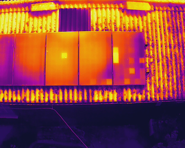
Clear evidence of solar panel faults in this thermal analysis image below.
Flat roofs
Find water ingress in flat roofs
Water getting into a flat roof can travel a long way before it shows inside, soaking the insulation as it goes. Wet insulation holds heat differently to dry, so when surveyed in the evening after a sunny day, saturated areas stand out clearly.
Because it’s non-invasive, a thermal roof survey helps target core samples and repairs exactly where they’re needed, and gives you dated evidence for warranty or insurance claims.
Pinpoint wet areas before the damage spreads, and repair only what needs repairing.
CAA
CAA Operational Authorisation 11363
Fully insured, with £10m public liability and specialist UAV cover
Why drones
Why use a drone for your thermal survey?
A handheld thermal camera only sees what can be reached from the ground. A drone captures every elevation and the whole roof from the right angle, in a single visit.
- No one at height. We survey roofs and elevations without ladders, scaffolding or access equipment.
- Whole building, one visit. Every elevation and roof area is captured from the ideal angle.
- Views you can’t get from the ground. Flat roofs, valleys and upper storeys are all covered.
- Thermal and visual together. Matching 4K images make every anomaly easy to find on site.
- Fast across portfolios. Housing providers and estates teams can survey many properties in a fraction of the time.
Thermal capture
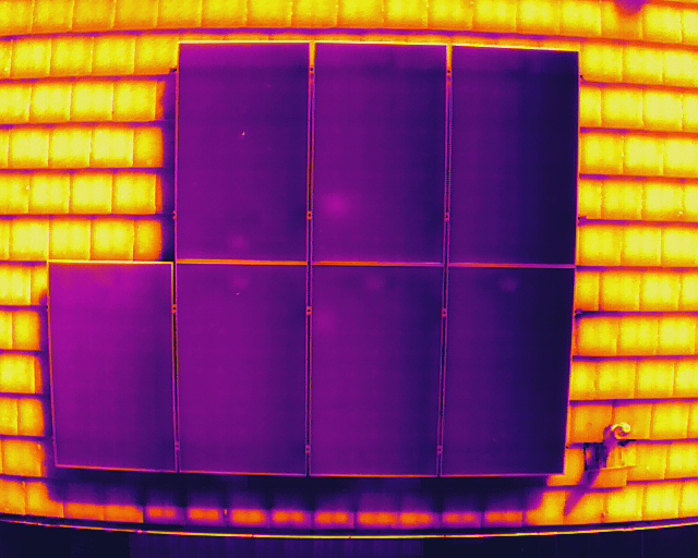
Solar Panels thermally mapped across the roof, with no one working at height.
Sectors We Cover
Thermal surveys for homes & commercial buildings
Anyone who pays for energy can benefit from a thermal survey. We survey houses, housing association stock, offices, schools, industrial units and large estates across the UK.
Our service is suitable for
- ›Offices and commercial premises
- ›Warehouses, factories and industrial buildings
- ›Retail units, shopping centres and retail parks
- ›Residential apartment blocks and housing developments
- ›Housing association and social housing properties
- ›Schools, colleges, universities and education estates
- ›Hospitals, clinics and other healthcare buildings
- ›Local authority and public-sector buildings
- ›Historic, heritage and listed buildings
- ›Hotels, leisure centres and hospitality properties
- ›Care homes and assisted-living facilities
- ›Distribution centres and logistics hubs
- ›Churches and places of worship
- ›Agricultural and rural buildings
- ›MOD, defence and secure estate buildings
- ›Prisons and custodial facilities
- ›Construction sites and newly completed developments
- ›Multi-site commercial and residential property portfolios
For clients with assets spread over large areas, we build a consistent visual library of the external envelope of every asset, helping teams compare condition and prioritise maintenance.
Why choose us
Why choose Drone Site Surveys?
Drone Site Surveys specialises in survey and inspection data capture, not general aerial photography. Our BINDT Level 2 qualified thermographers use drone-based thermal cameras to inspect roofs, façades and hard-to-reach areas without scaffolding. Each survey is planned around the right conditions, so heat loss, moisture ingress and hidden defects are captured accurately and explained clearly.
Clients choose Drone Site Surveys for our specialist experience, professional standards and independent approach:






How it works
Our drone thermal survey process
From first enquiry to secure delivery, every survey follows the same six steps, so you always know what happens next and when.
Tell us about the property
Email us the address with postcode and what you need, whether that’s a heat loss survey, solar panel analysis, a flat roof moisture survey or a full thermographer’s report. We’ll come back with the options available.
Planning and quote
We carry out a desktop assessment of the property and the surrounding airspace, check the survey against current UK drone regulations, and prepare your quote. You receive it by email with no obligation, along with the airspace map for your site and an example delivery so you can see exactly what you’ll be getting.
Booking your date
Once you’re happy with the quote we add your job to the schedule and start monitoring the Met Office forecast. In the meantime we prepare the pre-flight paperwork, including our risk assessment and method statement (RAMS), which we can send over for your records. As soon as we have a clear weather window and pilot availability, we confirm your attendance date. You don’t normally need to be on site.
The survey
Our CAA approved pilot captures every elevation and roof area in radiometric thermal and UHD 4K, in the right weather conditions for accurate readings.
Processing
Every image is checked and organised into colour-coded folders. Any thermal analysis or reporting you’ve asked for is completed at this stage.
Delivery
We email you a link to our secure online portal, where your imagery, reports and any other agreed outputs are ready to view, download and share with your team or contractors. Alongside the deliverables you’ll find a folder containing the pre-flight paperwork, a copy of the drone airspace map for your site and any other relevant documents, so everything from the survey is in one place.
Request a Quote
Request a drone thermal survey quote
Whether you’re chasing a known leak or want to cut your heating bills, know if your solar panels are operating at peak output, we can tailor the survey to your building and your requirements.
Send us the address and a brief description of what you need, and we will come back with clear pricing and deliverable options.
Prefer to Speak to Us?
If you’d rather speak to one of the team, that’s no problem. Simply call the number below and one of our team will be more than happy to help.
Get a Quote
In The Know
Frequently Asked
Questions
Answers to the questions we are asked most often about drone thermal surveys. If yours is not covered here, give us a call.
What is a drone thermal survey?
A drone thermal survey uses a radiometric thermal camera flown on a drone to measure surface temperatures across a building’s roof and elevations. Differences in temperature reveal heat loss, missing insulation, cold bridging and water ingress that can’t be seen with the naked eye.
When is the best time for a thermal survey?
Building thermography works best when there’s a big difference between inside and outside temperatures, ideally at least 10°C, so surveys are usually carried out between autumn and spring, early in the morning or after dark. Surfaces need to be dry, out of direct sun, and it can’t be too windy.
Can a thermal survey find roof leaks?
Yes. On flat roofs, wet insulation holds heat differently to dry insulation, so saturated areas show up clearly when surveyed in the evening after a sunny day. This helps target core samples and repairs.
What’s the difference between a thermal survey and a heat loss survey?
A heat loss survey is a type of thermal survey focused on where energy is escaping from a building. A thermal survey can also look for water ingress, damp and other defects. Find out more about heat loss surveys.
Who analyses the thermal images?
Our BINDT Level 2 qualified thermographers interpret the images, so anomalies are explained in context rather than left for you to guess.
What is a radiometric thermal camera?
A thermal camera that records a temperature value for every pixel in the image. That lets our thermographers measure and compare temperatures after the flight, rather than relying on colours alone.
Can you survey a whole housing portfolio?
Yes. Drones can cover large numbers of properties far faster than surveying from the ground, helping housing associations and landlords find and prioritise the properties with the biggest problems.
Do I need to be there during the survey?
Not usually, but we may ask for the heating to be on for several hours beforehand so there’s a good temperature difference. We just need safe access to a take-off area near the property.
Do you provide a written report?
Yes. Our Level 2 qualified thermographers produce a report with annotated thermal and visual images, explaining each anomaly and what is likely to be causing it.